Out in the Open: Creating a Stormwater Park in the Heart of a Community
By Steve Trinkaus
The management of stormwater is often considered an undesirable aspect of land development. The stormwater management system is typically hidden from view and expected to do its job without being seen or heard. The Town of Norfolk in northwest Connecticut is taking a different approach, embracing stormwater management by incorporating it into a public amenity in the center of the community.
Site Description
Norfolk is a small community of 1,700 spanning approximately 46.4 square miles. The center of the community overlooks an area known as the "City Meadow." The meadow was originally used as a grazing area for local cows in the late 1800s and early 1900s but as the town's commercial center developed around it, agricultural use of the meadow ceased.
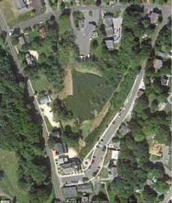
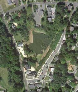
As shown in Figure 1, the City Meadow effectively separates the two main commercial sections of the town center and creates a lack of public continuity in the town center. In the early 1940s, drainage from the adjacent state and local road networks was discharged into the meadow at the southern and eastern portions. As the duration of discharge increased, the soil profile changed and it became a poorly drained soil. The runoff has eroded a channel to the north along the western side of the meadow but the channel does not provide any water quality benefit and is strictly a conveyance system.
The Blackberry River flows through a portion of the Town of Norfolk and this portion of the river is listed on the State 303d as impaired for nutrients. Water testing determined that stormwater was the primary source of the impairment. The town wanted to address this by creating a "stormwater park" in the City Meadow.
Project Description
The stormwater treatment system has not only been designed to reduce the pollutant loads from the runoff but also to function as a public amenity. The Stormwater Park will include pedestrian features to provide a connection to the existing commercial center of the town and encourage the public to passively use this area.
From a water quality perspective, the primary pollutants of concern are phosphorus, nitrogen, total suspended solids, metals, and hydrocarbons. In order to reduce these pollutant loads, the design utilized a treatment train approach including a forebay, wet swales, stone swales, a constructed wetland system and a deep water pond. Stone swales were incorporated to create an open water feature where two small waterfalls will increase the oxygen levels in the water.
Design of the Treatment System
The watershed area was determined to be 21.59 acres and consists of a mix of roadways and predominantly single family residences. The peak rate of runoff was determined for the two-year storm (21.19 cfs) and 10-year storm (43.68 cfs). The Water Quality Volume (WQV) for the contributing area was calculated to be 648.6 cubic feet.
The most important component of a stormwater treatment system is the forebay, a depressed area located at the inlet of a stormwater treatment system. The forebay must provide a minimum of 10% of the required WQV, have a depth of 4 to 6 feet and a length-to-width ratio of 3:1. These parameters are very important to permit coarse and some fine sediment particles to settle out and not be resuspended during future storm events.
After evaluating the topographic conditions on the site, it was determined that an Extended Detention Shallow Wetlands (EDSW) and deep water pond would be the primary treatment systems. These components were connected by either a wet swale or stepped stone swale to provide additional water quality improvement as well as a stable conveyance system that would not be subject to erosion.
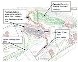
The EDSW was designed along the eastern side of the site at the base of the steep slope. It is approximately 290 feet in length with an average width of 50 feet, which provides a 5.8:1 ratio. Four areas of high marsh were created and the low marsh intertwining between the high marsh areas. At the northern end of the system, a 10-foot-deep micro-pool was created. A broad, shallow wet swale conveys the stormwater from the forebay to the EDSW.
A deep water pond was utilized to create a focal point in the park. In order to make the Stormwater Park attractive to the public, designers wanted to create unique features in conjunction with the stormwater treatment aspects. To accomplish that, the swale from the EDSW to the pond was designed as a natural stone channel. A narrow, shallow channel in the center of it was designed for stormwater from small events, while a larger channel section was utilized for larger storm flows.
As the swale had approximately a 15 foot drop, two stone water falls were built into the slope of the swale to create the sound of falling water as well as to aerate the flow. The swale had a curvilinear alignment to create interest on the landscape. Figure 2 shows the design of the stormwater components in the City Meadow.
Water Quality
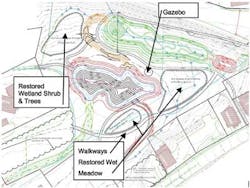
The forebay, wet swales, EDSW and open pond components of the treatment train will significantly reduce the current pollutant loads being discharged to the meadow. As shown in Table 1, nutrients will be reduced by over 60%, and TSS and metals by over 70%. These reductions will address the impairment in the Blackberry River over time. By removing invasive species and planting native wetland plants, portions of the meadow not being used for the treatment systems will be restored as native wetland meadows as an enhancement to the environment.
Public Access
Walking paths, which are fully handicap accessible, will wend their way through the stormwater park to connect the existing sidewalks on both sides of the meadow. Timber bridges will be used to cross the swales, exposing the public to the sights and sounds of running water. An open, covered gazebo will overlook the pond and provide a place for the public to sit and enjoy the surroundings.
Conclusions
The creation of a stormwater park in the currently degraded wetland of the City Meadow area is a unique approach to dealing with stormwater and its many adverse impacts. Not only will the stormwater park improve the water quality of the stormwater that ultimately reaches the Blackberry River but will create a connectiveness to the Norfolk town center that's currently absent. The design will encourage the public to enter and experience the recreated wetland environment that is the centerpiece of the Stormwater Park and experience the Norfolk town center in a new and positive manner.
This is the first known example of creating a stormwater park in Connecticut that will provide not only environmental benefits but a tangible public benefit as well. It is hoped that this concept will serve as a template for other communities wishing to address the adverse impacts of stormwater.
About the Author: Steve Trinkaus, PE, CPESC, CPSWQ, is the principal engineer for Trinkaus Engineering, LLC, in Southbury, CT. He has more than 28 years experience in the field of land development, specializing in residential and commercial projects. He is a nationally recognized expert in the application of Low Impact Development strategies, particularly in the development of LID regulations for municipalities.


