Rural Water District Goes High Accuracy on a Budget

May 1, 2017
At Le-Ax Water District the maintenance crew is responsible for gathering GPS points on assets. This used to be a daunting task due to the limited technical knowledge of the crew.

By Travis Anderson

At Le-Ax Water District the maintenance crew is responsible for gathering GPS points on assets. This used to be a daunting task due to the limited technical knowledge of the crew. There were challenges using the equipment and understanding the technology. In addition, there were delays while staff waited for the unit to achieve the required accuracy. Once the data was collected it needed to be processed and then imported into ArcMap. Collecting locations became a frustrating task for everyone involved.

Le-Ax needed a solution that was easy to use, that would collect accurate locations, and could be used offline. Since staff used tablets and smart phones daily for personal use, having a solution that would work on these devices was desirable. This would eliminate the challenge associated with new technology. So, I began to search for a solution.

With the Esri solution, Le-Ax was able to collect 8 cm accuracy online and half-meter accuracy (at the worst) offline.

When Collector for ArcGIS was released, I knew this would be our next step. Although I knew little about GIS, I was able to use Esri resources (online communities, help documentation, and support staff) to get started. Since we already had an ArcGIS for Desktop Basic seat and the yearly maintenance subscription, Esri provided us with one free ArcGIS Online account. After reading the basics on creating online maps and sharing them within our organization, I began uploading our layers and recreating our desktop GIS in ArcGIS Online. After I understood the concept, it took me about 30 minutes to recreate our desktop GIS as an online version.

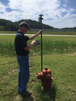
Although the initial pilot for Collector was a success we were not able to acquire the accuracy that we needed. This changed with the release of Collector 10.4, which included support for high-accuracy external receivers, including data transformations and the capture of metadata. We paired our devices with an Arrow receiver, connected to the Ohio Department of Transportation RTK, and were able to collect 8 cm accuracy online and half-meter accuracy (at the worst) offline. This put the finishing touches on an already great app.

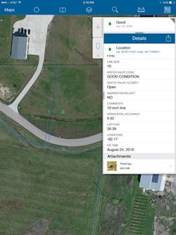
Screenshot of the Details panel.

As a final thought, I would be remiss if I didn’t mention something about the budget. Everyone has a budget that they would like to stick to and it’s very easy to spend an exorbitant amount of money on items related to GIS and GPS. I did not want to spend a large sum of money on an external receiver just to have it sit on a shelf. In the end, we invested around $3,700 dollars. We did have the yearly maintenance subscription for our seat of ArcGIS for Desktop Basic, which afforded us one free account to ArcGIS Online. We used that account to initially test and set up our online maps. We have since acquired a five-seat license for ArcGIS Online, so we can deploy multiple iPads in the field and allow office staff to take advantage of our online maps. The beauty of ArcGIS Online is that all your maps are accessible to anyone within the organization.

Travis Anderson is a district engineer with Le-Ax Water District (Athens, Ohio).

Esri is exhibiting at AWWA’s ACE17 expo in Booth 1825.

Sponsored Recommendations

ArmorBlock 5000: Boost Automation Efficiency

April 25, 2024
Discover the transformative benefits of leveraging a scalable On-Machine I/O to improve flexibility, enhance reliability and streamline operations.

Rising Cyber Threats and the Impact on Risk and Resiliency Operations

April 25, 2024
The world of manufacturing is changing, and Generative AI is one of the many change agents. The 2024 State of Smart Manufacturing Report takes a deep dive into how Generative ...

State of Smart Manufacturing Report Series

April 25, 2024
The world of manufacturing is changing, and Generative AI is one of the many change agents. The 2024 State of Smart Manufacturing Report takes a deep dive into how Generative ...

SmartSights WIN-911 Alarm Notification Software Enables Faster Response

March 15, 2024
Alarm notification software enables faster response for customers, keeping production on track