Road Testing PipeTrack for a Leading UK Water Company
Infotec’s gyroscopic pipeline tracking system aids Thames Water’s effort to map sewerage system
By David Pitt
Following introduction of the new PipeTrack gyroscopic pipeline tracking system at the No-Dig Live 2006 exhibition near Coventry, England, Infotec won an opportunity to trial it “in anger” by Thames Water. The project required accurate determination of the routes of numerous private lateral connections emanating from a major public trunk sewer. The test site provided a far from ideal opportunity of demonstrating unique advantages the distribution tracking system.
Accurate determination of the position of laterals, in both the vertical and horizontal dimensions, was required to avoid potential damage to existing drainage services during construction of a proposed new rail tunnel. Within the tunnel design route, its crown was destined to pass adjacent to the sewer, at some distance above its invert level.
Difficult Conditions
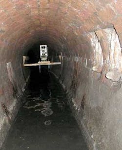
The difficulty with this particular mapping project was, in this instance, that the trunk sewer itself was a brick, egg shape of only 1,200mm x 813mm. The accessible bore was also further reduced by a 200mm depth of silt in the invert. Several of the 20+ lateral service connections due to be mapped also were found to be silted. But, as this adequately determined their lack of use, ultimately this meant there was no requirement for a survey of these particular laterals.
Remaining laterals were tracked from their point of connection with the trunk sewer for sufficient distance to determine their required route in relation to the proposed tunnel. This information was issued to Thames Water in a CAD format, along with a topographic survey, which included the cross-sectional profiling also required for the trunk sewer.
Accuracy achieved using the PipeTrack technique was less than 0.1% in the vertical alignment and 0.25% in the horizontal plane. No currently available alternative method would have been able to provide this level of information, as the accuracy achievable using sewer probing or similar techniques wouldn’t have been sufficient for the purpose at hand.
Also, given depth of the system, which was about 10 metres, combined with close proximity of many existing shallow services, including power and communications cables, gas and water pipes and traffic control sensors, use of sewer probing systems would have also proven largely unsuccessful. Given the depth, prevailing soil conditions and density of services, ground penetrating radar (gpr) scanning would also provide no acceptable alternative.
Duct Route Mapping
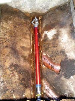
PipeTrack is the world’s first, fully self-contained pipe and duct route mapping system. It’s capable of mapping either between two known points, or from a single point of entry such as a lateral connection or rising main, etc. The data, which determines the route taken, is recorded within the on-board data storage system and requires no surface tracking or personnel access over the pipe route, eliminating the need to provide expensive and potentially disruptive traffic management procedures, as well as risk to survey personnel.
The system has no set limit on the length of survey (other than data storage capacity of the system), and it’s possible therefore to consider several kilometres of survey without need for intermittent data downloading.
Accurate data can be obtained at speeds of over 4.0 m/sec. This enables utility owners and/or their contractors to map entire catchment areas or pipeline networks at an extremely low cost per metre. Ability of the system to precisely determine the presence of backfalls or bellies in a pipe’s route also provides engineers with a unique opportunity to determine “hotspots” or identify specific areas requiring remedial repair.
This is an advantage not currently provided using either CCTV or probing systems. In addition, neither of these commonly used systems would enable subsequent groundwork’s or repairs to be clearly identified between a start and finish coordinate. This further enhances effective budgetary control on remedial repair costs.
Acknowledgments:
The author would like to thank NoDig Media Services’ Ian Clarke for his help on this article. Contact: [email protected] or www.nodigmedia.co.uk
Author’s Note:
David Pitt is managing director of Infotec Consulting, an engineering firm that specialises in underground utility mapping and surveying. UK distribution agent for PipeTrack, it’s based in Leigh-on-Sea, Essex, England. Contact: +44 (0) 1702 421 390, www.infotec1.net or www.pipetrack.co.uk


