Leveraging data to optimize shipping through the Panama Canal while protecting local water supply
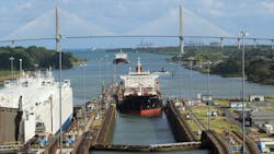
The Panama Canal, a 51-mile waterway connecting the Atlantic and Pacific Oceans, is considered the most vital piece of infrastructure for the transport of international trade in the Western Hemisphere.
This trans-oceanic corridor, which reduces vessel travel time between New York and San Francisco by more than half, supports 6% of global maritime trade as a primary route connecting North Asia and the East and Gulf Coasts of the United States. In 2003 alone, 14,000 vessels transited the Panama Canal, carrying more than 500 million tons of cargo.
The Panama Canal’s lock system is reliant on water from the Chagres River, which is stored in two manmade lakes: Gatun and Alajuela. Water from the lakes fills a series of locks that lift ships 85 feet above sea level to Gatun Lake and lowers them on the other side, allowing vessels to move freely between the Atlantic Ocean and the Pacific Ocean.
Managing the water levels in Gatun and Alajuela Lakes is critical to the Panama Canal’s function with a single vessel transit using 52 million gallons of fresh water and an average of 36 ships transiting the Canal per day. Maintaining sufficient water levels is also critical for the 2.5 million residents of Panama City and Colón who depend on the Chagres River for their drinking water and municipal wastewater treatment. Hydropower is generated in Gatun and Alhajuela, mostly for internal Canal operations.
The balancing act of maintaining optimal lake levels is carried out by the Panama Canal Authority (PCA). The agency accomplishes this by collecting and leveraging vast amounts of data, which is used for hydrological modeling and forecasting, to support strategies to economize the use of a finite resource.
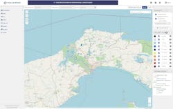
Scattered across the watersheds, 55 scientific stations collect information related to precipitation, water temperature, wind speeds, dewpoint, humidity, tides, water levels, and runoff. The PCA consolidates this raw data, along with S-band weather radar information in Aquarius, a software platform, that acquires, organizes, models, and assures data quality before publishing in real-time.
Using hydrological data to influence canal traffic
To optimize the use of water resources, the PCA must predict how much precipitation the watershed will receive during the rainy season, from May to December, and calculate how much water to save.
When lakes are too full, the agency must release precious water into the ocean to avoid flooding. When lake levels are low, as they were following a prolonged drought earlier this year, it must limit or discourage the number of ships transiting each day along with their weight, if possible, to reduce water draft restriction.
Members of PCA’s Operations Vice Presidency access data from the platform to determine transit charges, based on variable daily lake levels. When water levels are high, transit charges are lower to incentivize shipping companies to plan travel through the canal during times of abundant water supply. When lakes are lower, transit charges are considerably higher. PCA calculates these tariff values as well as draft restrictions with the hydrological data organized and managed in Aquarius.
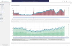
The software is designed to automate workflows by extracting data, turning it into meaningful information, and making it available to stakeholders that require it to do their job. PCA’s Hydrometeorology Division uses the sensor data to conduct predictive analytics and meteorological forecasting to identify weather patterns in advance and determine long-term strategies so the agency can make the most strategic and efficient use of the water resources as possible. The platform allows meteorologists to compare current data and numerical models with historical and analog data, which has elevated the accuracy of their forecasts.
Secure, accessible quality data serves the greater community
In the past, PCA had to gather and send data files manually to individual teams and outside agencies. The new platform provides a centralized, open-hub format via a web portal, making information easily accessible to all stakeholders as well as the public. With organized data and open access, PCA is able to work more efficiently since team members from across the organization can utilize any information that they might need.
Sensor data is automatically uploaded into the system with minimal manual intervention, so operators can have greater confidence in the data integrity. Automated error detections and intuitive correction tools allow PCA to compare current and historical data. PCA can make any corrections for quality assurance, with changes precisely annotated within the software system.
These traceable quality assurance and control procedure are invaluable features, as are the data stability and security that Aquarius’ cloud-based storage provides. The platform is hosted in a secure private cloud that alleviates PCA from having to maintain its own servers and software updates, while providing the latest in data security.
As industry and technology continue to evolve, cloud solutions can keep up with the changes in the background, ensuring users always have optimal tools. The canal’s web portal also ensures that the data is accessible to outside agencies, making it easy for IDAAN (Instituto de Acueductos y Alcantarillados Nacionales), Panama’s municipal water and sewage management agency, to access lake level data and incorporate it into its operations. This insight informs water treatment processes since low lake levels and saltwater intrusion can adversely affect pumps and water treatment processes. PCAs web portal provides up-to-date information and high-integrity data so that professionals across the organization and beyond can make the best use of it. The web portal is customizable so PCA can display information in charts, graphs, maps, meters and timelines making it easy for users to hone in on the information for which they are looking.
The Panama Canal’s hydrological data has impacts that extend far beyond the lock gates and local communities. When, for example, trade through the waterway is limited due to low water levels, transportation delays can result in shifts across the global economy — from elevating transport costs and affecting the availability of products worldwide to increasing the cost of groceries at neighborhood markets.
Using the Aquarius platform to manage data, PCA streamlines transportation costs and the flow of goods around the world, while also ensuring the people of Panama have the water they need.
About the Author
Alejandro Varela
Alejandro Varela is the strategic account manager for Aquatic Informatics in the USA and LATAM. Alejandro has an in-depth understanding of the water sector's unique challenges and opportunities, and delivers tailored software and instrumentation solutions to drive operational efficiency and optimize water management.


