Water Company Experiments With Non-Intrusive Underground Mapping Technology
By Olivier Lacquemanne
Ground-penetrating imaging radar technology is helping the New Jersey-American Water Company (NJAWC) locate its underground assets in Ortley Beach, NJ, without need for pick, shovel or spade. The company is using a non-intrusive mapping service from Schlumberger to locate pipes, valves and end-of-mains.
New Jersey-American is part of the American Water Works Service Company, the largest privately-owned water utility in the United States. In October 2000, NJAWC acquired the Ortley Beach Water Company from the local municipality, increasing the NJAWC customer base of 340,000 by a further 2,000.
Ortley Beach is a summer residence community on a barrier island on the New Jersey coast. The water utility there was suffering problems of low pressure in the system and water discoloration, which arose with normal use over time and as the original system was extended. Connections for new dwellings were added, some blank ends for future dwellings were not used and valves were covered with asphalt road construction without installing access chambers.
"When we took over at Ortley Beach the existing records consisted of just one map of underground assets, the accuracy of which could not be confirmed," said Bill Pearce, Vice President Engineering, NJAWC. "We knew from the start we had some work to do to locate valves and the dead-end mains."
Plans and Objectives
NJAWC approached Schlumberger in October 2000 to request a pilot demonstration of the UtiliLOG non-intrusive mapping service. The goal was to determine if the service could locate existing service routes and particularly the four-inch dead-end water mains at Ortley Beach.
An initial soil survey confirmed the uniform sandy soils on the island were ideal for the system's non-intrusive ground-penetrating imaging radar (GPiR) data acquisition, and Schlumberger put forward a proposal for a one-week pilot, which was accepted.
"To solve the low pressure problems, we needed to locate the existing valves to check if any were damaged or partially closed," Pearce said. "Although some have valve pits or inspection chambers, many are buried below the asphalt pavement and are difficult to find.
"We also wanted to locate the four-inch dead-ends and cross connections so that the system could be flushed out to clean the pipes and prevent discoloration of the supply," he said.
Mapping Technology
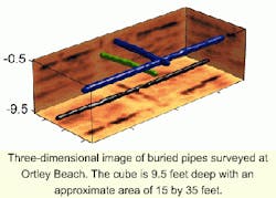
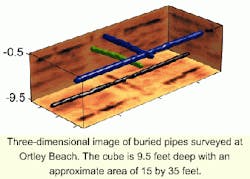
UtiliLOG uses radar scans and imaging algorithms to form a three dimensional map of an underground site. Its mobile Computer-Assisted Radar Tomography (CART) system can be used to pinpoint and record images of conductive and non-conductive utilities vertically and horizontally with an accuracy of better than one centimeter in any direction.
The CART system is a technology developed and owned by Witten Technologies of Boston, MA. Witten's CART-based underground mapping technologies and services are offered through a number of strategic service partners, including Schlumberger.
Emil Burnham of Schlumberger explains how the survey is carried out:
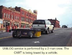
"Manned by a three-person Schlumberger crew, the computer controlled UtiliLOG CART is towed across the area to be surveyed, behind a sports utility vehicle. It covers a minimum of 500 linear meters in an hour. One pass over the ground is enough to form a full 3-D image of the ground under a swath two meters wide."
Raw data can be viewed on site within a few minutes. Further processing is then required to produce the full interpreted three dimensional image and map of identified underground utility features. Advanced geophysical signal processing algorithms initially developed in the oil industry are used to produce very high-resolution images of the subsurface. From these, manmade features can be delineated.
"Processed and interpreted three-dimensional maps are normally supplied to the customer within a few days of the survey," Burnham said. " In addition, as an option within the UtiliLOG service, we can add interpreted utility features - their description and precise location and depth - to the client's engineering Computer Aided Design (CAD) or Geographical Information System (GIS) computer software system for the utility network."
Operations and Results
The survey at Ortley Beach was carried out in January 2001. It covered about 15 percent of the total service area and was designed to establish the value of the UtiliLOG service for NJWAC.
"It made sense to do the survey work during the winter when the population of Ortley Beach is much reduced. That way we planned to keep disruption of roads and traffic to a minimum, and get the excavation work and improvements completed before people return for the summer," Pearce said.
Despite difficulties caused by severe weather, including snow, rain and freezing conditions, the site work was completed successfully. Twenty five locations of valves and dead-ends were identified by the survey. NJAWC has already dug four verification holes to confirm the accuracy of the results.
"It is spot on every time," Pearce said. "The results are excellent."
Reviewing the project so far, Pearce is pleased with the results. He is also ready to admit to learning some lessons about scheduling and management of the process.
"Like any tool, this is great technology when it is applied properly," he said. "We found that close co-operation between the Schlumberger CART team with their technical expertise and our own engineers with their knowledge of the water system is the most efficient way to maximize results."
Cost Justification
The cost justification of the work at Ortley Beach is relatively easy to make. Pearce made a comparison on a site specific basis: "As an example, in one location we saved at least two hours of excavation time through knowing exactly where to dig to find the valve - that is a saving of about 50 percent on what it might have been without the UtiliLOG data. When you are talking about a three-strong crew and digging equipment, the savings are significant."
At some sites, the data gathered may just confirm existing information, but excavations nearly always will be smaller and neater, requiring less re-construction after the work has been done. Where existing information is scanty or inaccurate, the overall process can be highly cost-effective.
NJAWC has plans for further survey work in Ortley Beach in the fall. "We want to install meters to measure the supply to individual properties and will need to locate the pipe entry point at each property line," Pearce said. "We hope to use the UtiliLOG service again to help us with that."
About the Author:
Olivier Lacquemanne is StreetLOG Manager at Schlumberger Integrated Water Solutions, based in Mexico City, Mexico. For more information, he can be contacted at [email protected].


