Ditching Paper Maps for Digital Apps
About 22 miles southwest of New York City, the City of Rahway is home to 30,000 residents. The Engineering Division regularly responds to internal and external information requests. Recently, the city created an initiative that would streamline such requests.
Modernizing Response to Records Requests
Decades ago, Rahway’s engineers captured high-quality information while mapping the city’s sanitary sewer and stormwater systems on paper forms called flat files.
“The original engineering flat files contained terrific information,” says Jacqueline Foushee, former DPW director and current city business administrator. “But over time, they became difficult to interpret, share, and update. Our goal was to get away from that. We envisioned having an enterprise GIS.”
Foushee received approval from Rahway mayor Raymond Giacobbe to implement an enterprise GIS. She identified the city’s upcoming MS4 inspections as the ideal project to start capturing information with the city’s GIS.Ditching Paper for Mobile Maps
The New Jersey Department of Environmental Protection requires MS4 Tier A municipalities to map and submit stormwater outfall locations in a digital GIS format. Foushee sought the help of Esri partner Colliers Engineering & Design to perform inspections, but also to map the entire stormwater and sanitary sewer system in the process.
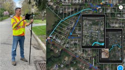
Colliers used ArcGIS Field Maps on Apple iPads to perform data-collection. In addition, the tracking capability enabled them to visualize GIS technicians’ real-time locations. This added efficiency and safety to their work.
“In the past, we might not have known if we mapped assets on a street or if there were simply no assets there,”
Colliers project manager, Michael Kolody says. “With Field Maps, the tracking record confirms that someone surveyed the street and there was nothing there. We can also see where each technician ended their day, which provides an extra layer of safety and monitoring.”
To ensure that assets were collected with six-inch accuracy or better, technicians paired Eos Arrow Gold GNSS receivers to the iPads running Field Maps. Technicians were able to log in to the New York Department of Transportation public RTK network to receive survey-grade, satellite-based location corrections.
“The combination of accuracy from the Arrow Gold, the seamless integration into ArcGIS Field Maps, and the iPad’s user-friendliness made this an easy-to-adopt mapping solution,” Kolody said. “It’s a solution our mobile teams actually like to use.”
After mapping locations of stormwater outfalls in Field Maps, Kolody’s team performed the inspections required for the MS4 Tier A permit, using a form the team created in ArcGIS Survey123.
Providing High-Quality Data to the City’s GIS
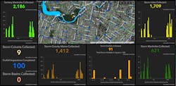
In just a few days, one GIS technician was able to capture the majority of the 4,750 municipal surface assets. ArcGIS Dashboards was used to allow Foushee’s team to see data-collection progress in real time.
Moving forward, Rahway will require all plans associated with awarded contracts to be submitted in GIS format. The long-term vision is to be able to expand the enterprise GIS beyond the Engineering Division and DPW. WW
Esri is an international supplier of geographic information system software, web GIS, and geodatabase management applications. Learn more at www.esri.com.
Published in WaterWorld magazine, August 2022.

