By Peter Frost and R. Randolph Ferguson
In 2002, the Douglasville-Douglas County Water and Sewer Authority (WSA) acquired the responsibility of managing stormwater infrastructure within the city of Douglasville and Douglas County. WSA took this action realizing that it was essential to assure a sustainable water future for city and county residents. All of WSA’s water supply resources, as well as wastewater and stormwater facilities, are located inside this rapidly growing county just west of Atlanta. An integrated approach to their management is critical for a sustainable water future.
Jordan, Jones & Goulding (JJG) has assisted WSA in developing a comprehensive stormwater management program, coordinated with other water infrastructure management. There were many lessons learned along the way, and changes necessary for WSA and its operations.
Organizational culture changes - Although WSA has long employed a cross-training program for its employees across the water and wastewater disciplines, adding a completely new skill set was a challenge that required a shift in the organization’s culture. An evolution was necessary to enlarge WSA departments that previously managed only drinking water and wastewater to include staff with skills in the stormwater arena.
A business-oriented model - WSA has historically functioned more like a business than a utility. This proved especially helpful as stormwater responsibilities were added to its operations. The Authority determined that many functions, staff and equipment could be used in all three areas (water, wastewater and stormwater), resulting in cost-efficiencies and maximum use of resources.
Reality vs. perception - Although information from both the city and county about existing stormwater infrastructure was provided prior to WSA assuming these assets, the magnitude of the challenges turned out to be far greater than expected. A primary consideration for any agency taking over an existing stormwater system should be to never underestimate the effort needed to inventory, categorize and fix stormwater problems.
Public reaction and education - Although WSA inherited the problems in the stormwater system, public reaction focused on anger with the lack of maintenance that put the community in this position. WSA learned the public can be educated about the issues related to stormwater and, in fact, “converted” into stormwater stewards.
Importance of technical data - Early on, WSA realized it was imperative to prepare flood plain studies that looked at the big picture. This enabled them to take an organized approach to fixing the problems, rather than moving forward with piecemeal fixes that potentially created additional problems downstream.
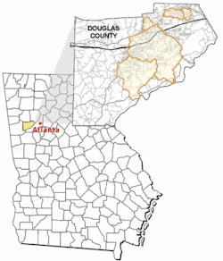
Modeled watersheds in Douglas county, just west of Atlanta.
Prioritization - WSA found that the task was two-fold: “putting out fires” with immediate problems, while developing a long-range approach so mistakes would not be repeated. Juggling priorities to address both of these issues proved complex but necessary.
Taking Over Stormwater Management
In February 2003, JJG began working with WSA to develop and implement a stormwater program for only the jurisdictional areas of the city of Douglasville. In 2004, the project expanded to include unincorporated areas of Douglas County and a complete inventory of all stormwater assets in the county.
Part of the project required identification and valuation of catch basins, conveyance pipes and detention ponds that were being transferred to DDCWSA ownership from the city of Douglasville in 2003 and Douglas County in 2004. JJG completed the first valuation of city assets needed for compliance with GASB-34 financial reporting requirements in an expedited timeframe using the best data available at the time.
As the authority was planning to assume control and ownership of the county’s stormwater program and assets in 2004, it became clear that a comprehensive city- and county-wide inventory of stormwater infrastructure was needed. JJG developed a comprehensive GIS-based data management model used to capture, store and process all data related to the overall stormwater program. The firm ultimately assisted DDCWSA in the capture of updated orthophotography and LiDAR topography data, as well as parcel, impervious area, drainage complaint and stormwater infrastructure data.
Stormwater Inventory
Once the stormwater utility and management plan activity was expanded to all of Douglas County, JJG worked with a local surveyor to develop an inventory of all public right-of-way stormwater infrastructure. The inventory was completed using mapping grade GPS technology and field data loggers. All shape files and data attributes were loaded into an ArcView geodatabase and set up for viewing by any WSA user employing an ArcReader browser.
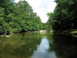
The Slater Mill Creek watershed was used as a pilot for other basin studies.
Over 9,400 inlets, outlets and junctions, and over 12,000 pipes and culverts were collected and processed during the course of the 11-month field effort. The data management system is now able to support the Authority’s maintenance and repair efforts, NPDES (stormwater) permitting requirements, capital improvement planning and prioritization, and ongoing asset valuation and management needs. JJG is currently using the inventory data to support detailed flood studies being conducted to update FEMA Flood Insurance Rate Maps and future floodplain limits required by the Metro North Georgia Water Planning District.
Public Outreach
Many communities have adopted the approach of funding stormwater issues through a user fee typically a stormwater utility much like is done for water and sewer utilities. However, many consumers of the stormwater services do not readily understand the need for the stormwater user charge, and are often opposed to the concept of the stormwater utility. One reason is that stormwater services, unlike other utilities that can be metered, are difficult to quantify.
The stormwater utility fee was seen as another component of the education process for WSA customers, even for those who were not currently being charged drinking water and wastewater fees. An organized communication effort was developed, including bill inserts, presentations to community groups, website information, advertisements and articles in the local newspaper, displays in the WSA offices and other techniques. The approach was proactive and far-reaching, resulting in few complaints or calls from property owners objecting to the stormwater fee.
Stormwater Videos
Another successful component of WSA’s outreach was a video series developed for the Authority by JJG. This approach allowed facts to be presented as visual concepts. Designed to address both stormwater problems and the solutions at the individual level, the videos expose the public to the full array of stormwater challenges that they must help solve.
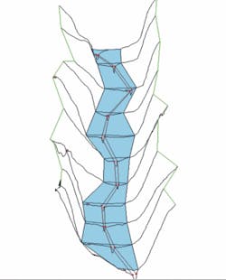
3-Dimensional flood plain mapping illustrates areas likely to sustain damages.
Once aware of the magnitude of the problems stormwater management can present, the public can begin to recognize how individuals can have an impact upon the problem and contribute to the solution, and what range of funding is required to solve those problems. Higher public awareness also helped WSA create a more favorable environment for the introduction of a stormwater utility and user fee.
Technical Components
The WSA began the process of implementing stormwater solutions with the Slater Mill Creek Capital Improvement Program and Watershed Action Plan project. While the goal of the project was to identify solutions to flooding, stream bank erosion and water quality problems, WSA also chose to define protocols for using county-wide data (survey, imagery, etc.), previous watershed assessment data, and floodplain modeling and mapping tools. This blueprint included a data management (GIS) and modeling needs assessment, considered implementation of tasks on a county-wide scale to achieve economy-of-scale benefits, and built off of the planning framework established by regulatory entities in the region. It thus ensured that the authority complied with the mandates of the NPDES Phase II Program and the Metropolitan North Georgia Water Planning District. The latter organization, which encompasses 16 counties in the greater Atlanta area, has adopted guidelines for floodplain mapping that are more stringent than those typically required by FEMA.
These guidelines were addressed through the development of floodplain maps to identify areas sensitive to damages from current flooding or potential future improvements. The WSA now has a map-based management tool that will illustrate property and drainage structures at risk from flooding damage. All floodplain analyses were performed such that maps can be generated that meet FEMA approval for its ongoing Map Modernization Program.
The mapping projects have been organized into two phases to allow for greater value to be achieved in performing preliminary analyses on larger watershed scales (Phase I), while limiting in-depth analyses and reporting to smaller areas of immediate interest to the Authority (Phase II):
- Phase I: Base Model and Mapping. This will lay the groundwork for entire watersheds to be analyzed and enable WSA to select smaller basins for detailed analyses as part of Phase II. The major tasks for this phase are hydrologic and hydraulic modeling and floodplain mapping.
- Phase II: Final Floodplain Mapping and Basin Implementation Studies. Phase II services (now underway) include the analyses required to refine the extent of the stormwater problems identified in Phase I and to develop updated FEMA floodplain maps. Phase II services will be implemented on a smaller (basin) scale.
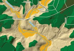
GIS-based mapping of floodplains helps local officials make informed land-use decisions.
By successfully adding stormwater infrastructure and management programs to its existing water and sewer programs in Douglasville and Douglas County, WSA is steadily moving toward truly integrating water management so that its various divisions do not operate in isolation, but work to protect and make wise use of the county’s water resources on a sustainable basis.
About the Authors:
Peter Frost is Executive Director, Douglasville-Douglas County Water and Sewer Authority, 8763 Hospital Drive, Douglasville, GA 30134; R. Randolph Ferguson, P.E., is Environment and Water Resources Service Leader, Jordan, Jones & Goulding, Inc., 6801 Governors Lake Parkway, Building 200, Norcross, GA 30071.


